


Voting Districts not defined, Presque Isle County, Michigan
About
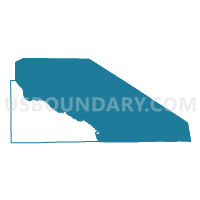
Outline

Summary
| Unique Area Identifier | 599303 |
| Name | Voting Districts not defined |
| County | Presque Isle County |
| State | Michigan |
| Area (square miles) | 1,888.28 |
| Land Area (square miles) | 0.00 |
| Water Area (square miles) | 1,888.28 |
| % of Land Area | 0.00 |
| % of Water Area | 100.00 |
| Latitude of the Internal Point | 45.48914080 |
| Longtitude of the Internal Point | -83.38501640 |
Maps

Graphs
Select a template below for downloading or customizing gragh for Voting Districts not defined, Presque Isle County, Michigan


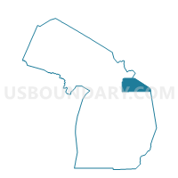
Neighbors
Neighoring Voting District (by Name) Neighboring Voting District on the Map
- Voting District 0070176000001, Alpena County, MI
- Voting District 0310742000001, Cheboygan County, MI
- Voting District 1410640000001, Presque Isle County, MI
- Voting District 1414390000001, Presque Isle County, MI
- Voting District 1416016000001, Presque Isle County, MI
- Voting District 1416634000001, Presque Isle County, MI
- Voting District 1416646000001, Presque Isle County, MI
- Voting District 1416924000001, Presque Isle County, MI
- Voting District 1416926000001, Presque Isle County, MI
- Voting District 1416926000002, Presque Isle County, MI
- Voting Districts not defined, Chippewa County, MI
- Voting Districts not defined, Mackinac County, MI
- Voting Districts not defined, Alpena County, MI
- Voting Districts not defined, Cheboygan County, MI
Top 10 Neighboring County Subdivision (by Population) Neighboring County Subdivision on the Map
- Alpena township, Alpena County, MI (9,060)
- Benton township, Cheboygan County, MI (3,206)
- Rogers City city, Presque Isle County, MI (2,827)
- Presque Isle township, Presque Isle County, MI (1,656)
- Rogers township, Presque Isle County, MI (984)
- Krakow township, Presque Isle County, MI (705)
- Ocqueoc township, Presque Isle County, MI (655)
- Bearinger township, Presque Isle County, MI (369)
- Pulawski township, Presque Isle County, MI (343)
- County subdivisions not defined, Presque Isle County, MI (0)
Top 10 Neighboring Place (by Population) Neighboring Place on the Map
Top 10 Neighboring Unified School District (by Population) Neighboring Unified School District on the Map
- Alpena Public Schools, MI (31,006)
- Cheboygan Area Schools, MI (14,220)
- Onaway Area Community School District, MI (5,778)
- Rogers City Area Schools, MI (5,349)
- Les Cheneaux Community Schools, MI (2,279)
- DeTour Area Schools, MI (2,190)
- Posen Consolidated School District, MI (1,983)
- School District Not Defined (Water), MI (243)
Top 10 Neighboring State Legislative District Lower Chamber (by Population) Neighboring State Legislative District Lower Chamber on the Map
- State House District 105, MI (95,524)
- State House District 107, MI (86,648)
- State House District 106, MI (86,395)
Top 10 Neighboring State Legislative District Upper Chamber (by Population) Neighboring State Legislative District Upper Chamber on the Map
Top 10 Neighboring 111th Congressional District (by Population) Neighboring 111th Congressional District on the Map
Top 10 Neighboring Census Tract (by Population) Neighboring Census Tract on the Map
- Census Tract 9604, Cheboygan County, MI (3,629)
- Census Tract 3, Alpena County, MI (3,204)
- Census Tract 9505, Presque Isle County, MI (2,679)
- Census Tract 9502, Presque Isle County, MI (2,614)
- Census Tract 9501, Presque Isle County, MI (1,971)
- Census Tract 9506, Presque Isle County, MI (1,375)
- Census Tract 9901, Chippewa County, MI (0)
- Census Tract 9900, Cheboygan County, MI (0)
- Census Tract 9900, Presque Isle County, MI (0)
- Census Tract 9900, Alpena County, MI (0)